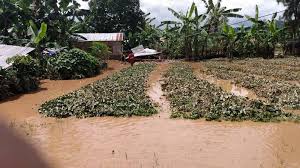
APA – Kigali (Rwanda) – Landslides triggered by underground water in Kamonyi, a district located about an hour’s drive from Kigali in Southern Rwanda early Thursday destroyed large tracks of farmlands, local administrative officials said.
Local communities from Nyarubaka, a mountainous village in Kamonyi district were the most affected where 3 hectares of crops were destroyed, according to local authorities.
Rwanda regularly experiences flooding during the period between February and May, most frequently in the central and southern and Western parts that tend to receive the most rainfall.
Predictions released earlier this week by the IGAD Climate Prediction and Applications Centre (ICPAC) indicate parts of the Great Horn of Africa are expected to experience such wetter conditions including Kenya, Somalia, southern Ethiopia, South Sudan, Uganda, Burundi, Rwanda, and north-western Tanzania.
The expected enhanced rainfall is likely to positively impact agriculture, water resources, and overall livelihoods, it said.
An early to normal rainfall onset is expected in several parts of the region. These include parts of northern Tanzania, eastern Rwanda, southern and western Uganda, western Kenya, south-western Somalia, and parts of south-central Ethiopia.
In line with the World Meteorological Organisation’s guidelines and recommendations, ICPAC has adopted an objective seasonal forecast method to generate climate forecasts for the Greater Horn of Africa.
Rwanda is expected to release the March to May (MAM) 2024 seasonal forecast during the climate outlook forum (COF) scheduled to take place on Friday in the capital Kigali.
CU/as/APA


